


")
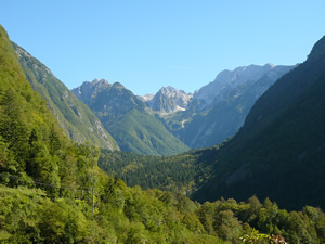
Bavšica Valley
Semi-demanding biking tour leads to the remote Bavšica Valley near Bovec.
Details
- Route: Kluže Fortress - Bavšica - Kluže Fortress
- Trail: semi demanding
- Suitable for: mountain and road bikes
- Length: 7.9 km
- Altitude difference: 220 m
- Download GPS Garmin: bavsica.gdb
- Download GPS XML: bavsica.gpx
Route description
The trail begins at the Kluže Fortress and turns right at the bridge over the Koritnica River to the Bavšica Valley. At first, the asphalt road descends, but after short flat section it continues via a long and steep ascent. At the top of the slope, the hamlet of Spodnja Bavšica is reached from where the view of the whole valley opens up. The trail continues via a flat section past Matijev čebelnjak (Matija’s Bee-House) and the hamlet of Zgornja Bavšica up to the Alpine learning centre at the end of the valley. Return is made via the same route.
Points of interest
The end of this trail can serve as a starting point for a mountaineering experience climbing Mt. Bavški Grintavec. In addition to visiting the Kluže Fortress and Matija’s Bee-House, the trail to the Bavšica Valley also offers beautiful views of the surrounding peaks.
Map and elevation profile of trail

Photo Gallery


|

|

|

|

|

|

|
