Apartments Casa Alpina Bovec
Apartmaji Tajcr
Kayak Soča

Bovec

Turist Info Portal

  • Slovenščina
  • English (UK)
  • Home
    • Bovec Webcams
    • Water levels
  • Accommodation
    • Apartments and rooms
    • Holiday houses
    • Hotels and Guesthouses
    • Campsites
  • Sport activities
    • Sport agencies
    • Rafting and kayaking
    • Cycling and MTB
    • Hiking and trekking
  • Interactive Map
  • Photo Gallery
    • Mountains
    • Waterfalls
    • Bavšica Valley
    • Lepena Valley
  • Advertise

Accommodations

  • Apartments and rooms
  • Holiday houses
  • Hotels and Guesthouses
  • Campsites

Cycling & MTB trails

  • Bovec Western route
  • Bovec Eastern route
  • Bovec Northern route
  • Bavšica Valley
  • Lepena Valley
  • Vrsnik Valley
  • Zadnjica Valley
  • Source of Soča river
  • Vršič Pass
  • Predel Pass
  • Mangart Saddle
  • Mount Stol ridge

Hiking and Trekking

  • Vodenca Jablanca
  • Source of Glijun creek
  • Zavrzelno
  • Kukč
  • Abandoned hamlet Lemovlje
  • Zadnjica Valley
  • Log pod Mangartom

Sport activities

  • Sport agencies

Graphical presentation of river levels

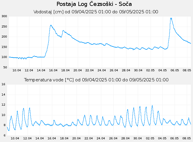
Graphs of river levels of Soča river and Koritnica river for the last 30 days.

Water level Soca Bovec


Water levels Koritnice Bovec

Sitemap

Copyright © Inkanet. All Rights Reserved.

info@bovec.org